US-20 Ashton to SH-87 JC
Skip to main content MenuWelcome
Welcome to the US-20 Ashton to SH-87 JCT Summer 2024 Online Meeting.
The purpose of the meeting is to provide an update on the Planning and Environmental Linkages (PEL) study and share the latest alternatives.

Click image to enlarge
How to Navigate:
- Click on the arrows on the bottom left and right side of your screen
- Use the navigation menu at the left of the screen to revisit any part of the meeting
- The pages are intended to be viewed in order to provide information about the study. However, you may use the tabs on the left side of the page to select any page
How to Participate:
- Click through the slides to learn more about the project
- Comments
- Provide your comments at any time by clicking the “ COMMENT" button at the top right of the screen.
- You can close the form to continue through the slides. Please make sure to hit the “Submit” button to confirm that your comment is sent to the project team.
- The entire session should take less than 15 minutes to complete.
Study Background
What is a Planning and Environmental Linkages (PEL) Study?
The PEL process considers environmental, community, and economic goals early on while planning future projects.
This process is outlined by the Federal Highway Administration and weighs:
- Transportation Issues and Priorities
- Environmental Resources and Concerns
- Stakeholder and Public Concerns
To learn more about the steps that take place during a PEL process, watch this video.
Why is the PEL study being conducted?
ITD is conducting the study to begin the long-term planning process for addressing traffic growth in the corridor. The study is looking at reducing the severity of crashes, improving access to businesses and properties along US-20 and addressing freight movement.
What is the vision for the study area?
ITD’s vision for the US-20 Ashton to SH-87 JCT corridor area is to provide safe and reliable travel for the planning year of 2050.

Click image to enlarge
Study Update
Since community meetings last summer, ITD enhanced its public involvement effort. In the past year, ITD has done the following:
- Met with additional stakeholders
- Held additional public meetings
- Collected additional traffic data to verify previously acquired projections used for screening
- Used the data to continue screening alternatives
The results of this Level 3 screening are presented here. Please view each alternative and share your feedback.
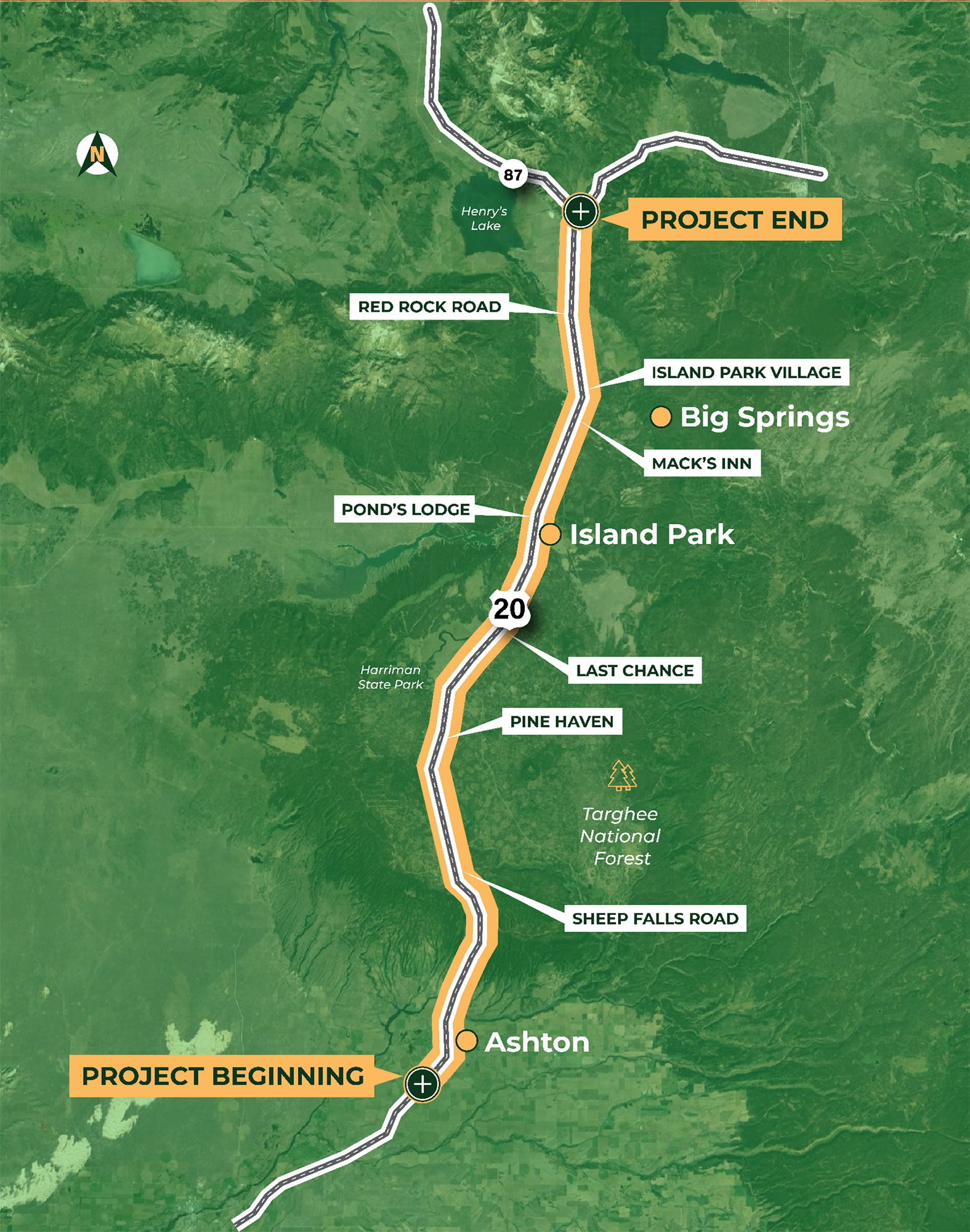
Click image to enlarge
Screening Process
The Planning and Environmental Linkages (PEL) study is looking at future, long-term (25+ years) transportation improvements. Since the study was initiated in 2021, ITD has developed a wide range of alternatives and screened those potential improvements to determine if they meet the project’s purpose and need.
Screening consists of evaluating each alternative against set criteria such as:
- Safety
- Traffic Operations
- Mobility
- Access Management
- Environmental Resources
- Constructability
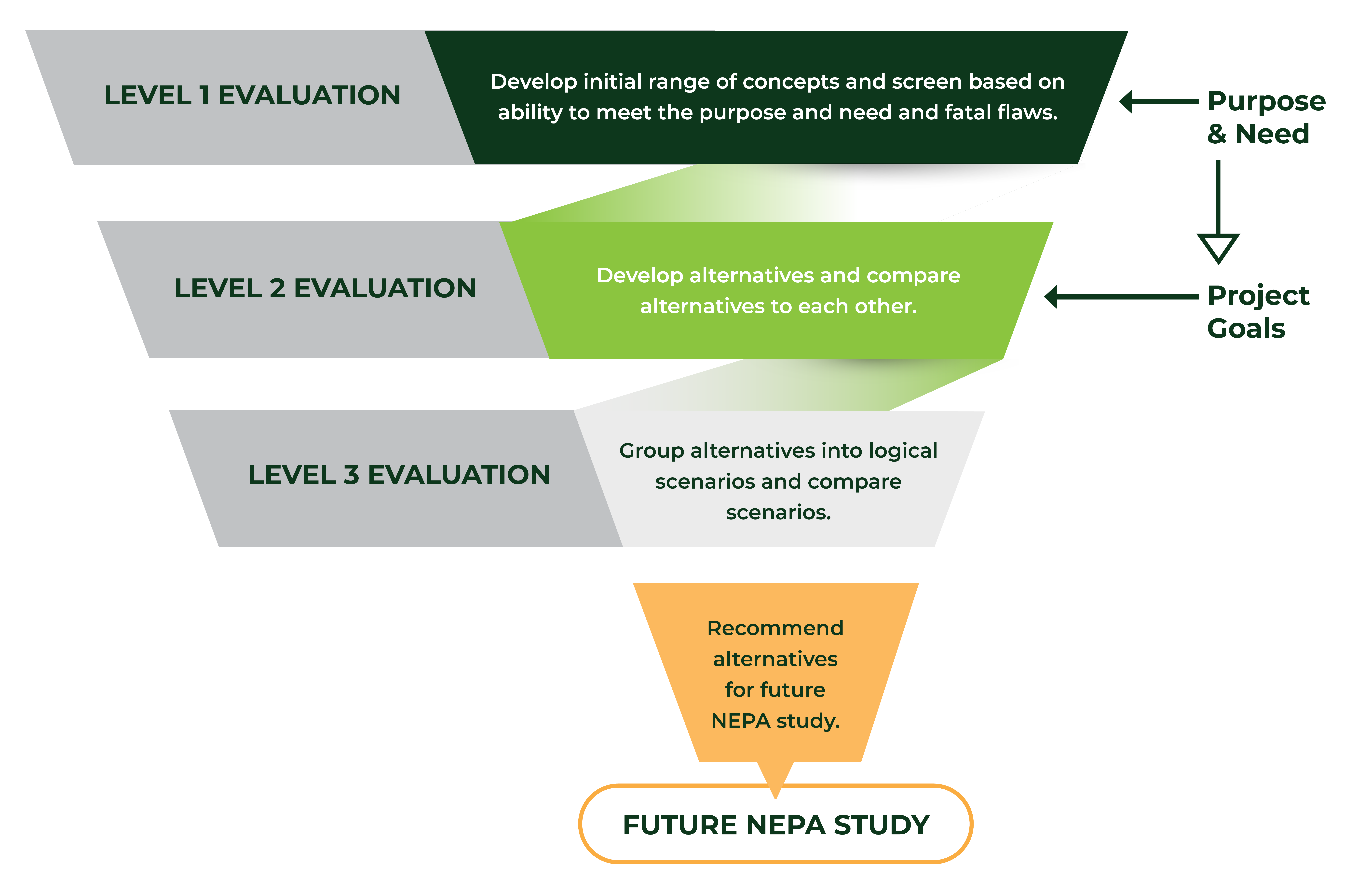
Click image to enlarge
Purpose and Need
What is a Purpose and Need?
The Purpose and Need provides the framework for evaluating the alternatives, leading to the study’s recommendations. The Purpose and Need is used to screen reasonable alternatives.
What is a Goal?
Goals are the desired project outcomes beyond the Purpose and Need that provide additional guidance for assessing reasonable alternatives, based on stakeholder and community input. Goals help balance environmental, transportation, and other community values.
The Ashton to SH-87 Junction section of US-20 was originally built in the 1950s. The current roadway does not provide sufficient traffic flow or passing opportunities to accommodate growing traffic volumes. The roadway has exceeded its service life and requires improvements to roadway and drainage features. Reconstruction will provide the opportunity to include design elements that reduce the severity and frequency of crashes.
Purpose
The purpose of the US-20 Ashton to SH-87 Junction Project is to enhance highway safety and operations by:
- Decreasing crash severity
- Addressing traffic growth in the corridor
- Improving access management
- Addressing regional freight movement
Need
The need for improvements to the US-20 corridor is to:
- Address existing deficiencies, such as:
- Safety
- Travel time
- Congestion
- Delays
- Prepare for future growth, economic development and tourism in the region
- Address freight mobility
Goals
When consulting with the public and resource agencies, ITD identified additional goals to be considered as the study is developed:
- Provide traffic calming measures or separation where the US-20 alignment runs through the developed areas
- Provide multiuse solutions that provide a range of options for recreational users
- Integrate wildlife movement strategies in the corridor
Alternatives
ITD used public and stakeholder input, planning best practices, and collaboration with agencies and jurisdictions to develop a range of alternatives that have been evaluated or “screened” to determine how to best meet the Purpose and Need of the study.
Alternatives that don’t meet the criteria or have fatal flaws are not carried forward for further analysis. Alternatives needing refinement are modified to reflect stakeholder and agency suggestions or regulatory requirements.
ITD anticipates incorporating recommendations made as part of this planning study into future NEPA studies, per Title 23 of the US Code, Part 168.
For more information, view the Level 1, Level 2, Level 3, and Multi-Use Crossing maps. If asked to sign in, please hit cancel and you will be entered into the site.
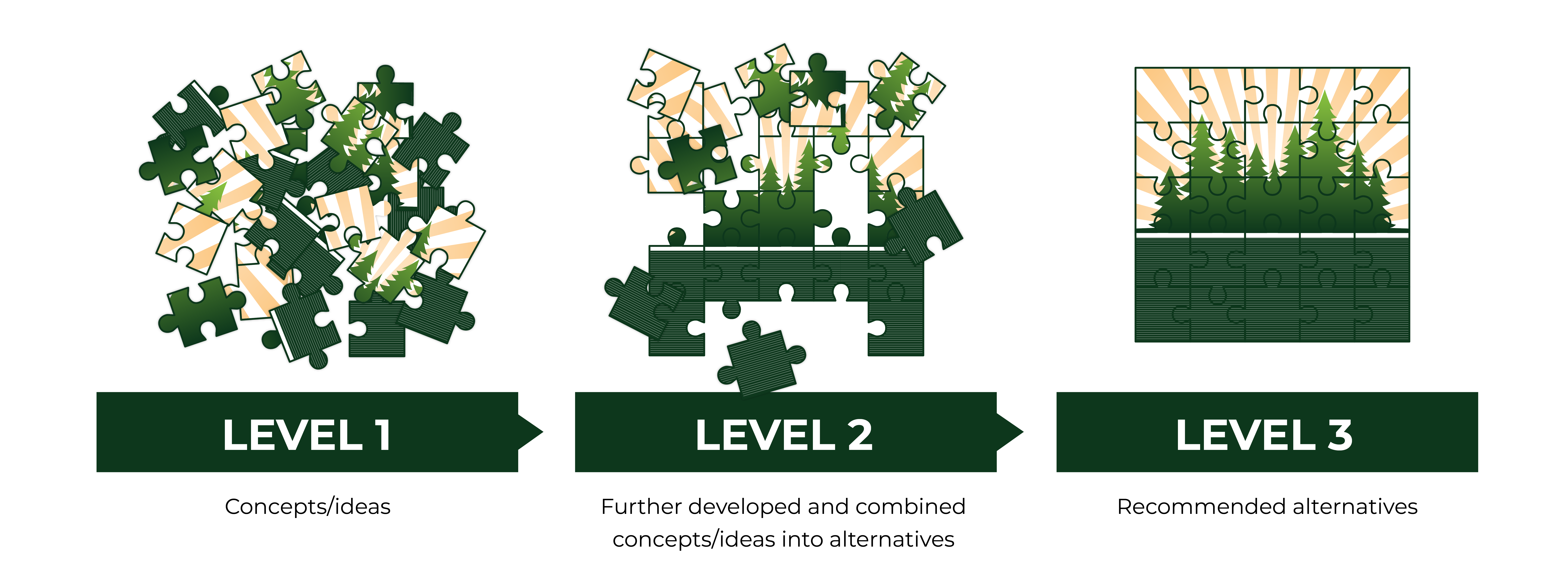
Click image to enlarge
- Ashton to Caldera Rim
- Pinehaven
- Last Chance
- Pond's Lodge
- Elk Creek
- Mack's Inn
- Island Park Village
- Red Rock Road
- Valley View Area
Ashton to Caldera Rim (AC)
 AC2
AC2

 AC3
AC3

Click image to enlarge
| Ashton to Caldera Rim (AC) | ||||
|---|---|---|---|---|
| At-grade (AG), Grade separated (GS), Alternating Passing Lanes (APL) | ||||
| Level 3 Alternatives | Roadway Lanes | Action | Reasons | |
| AC0 | AG | Carried Forward |
|
|
| AC2 | AG & GS | Carried Forward |
Additional Items to Consider:
|
|
| AC3 | AG & GS | Carried Forward |
Additional Items to Consider:
|
|
Pinehaven (PH)
 PH2
PH2
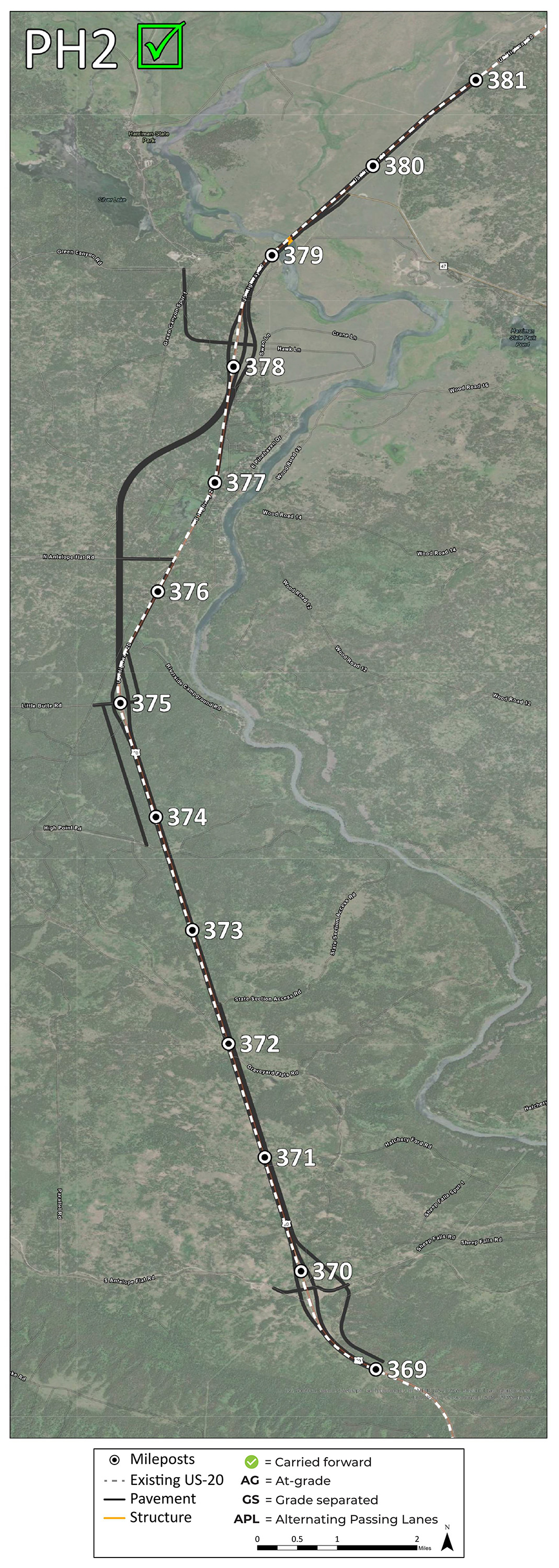
Click image to enlarge
| Pinehaven (PH) | ||||
|---|---|---|---|---|
| At-grade (AG), Grade separated (GS), Alternating Passing Lanes (APL) | ||||
| Level 3 Alternatives | Roadway Lanes | Action | Reasons | |
| PH0 | AG | Carried Forward |
|
|
| PH1 | AG & GS | Does Not Advance |
|
|
| PH2 | AG & GS | Carried Forward |
Additional Items to Consider:
|
|
Last Chance (LC)
 LC2
LC2

Click image to enlarge
| Last Chance (LC) | ||||
|---|---|---|---|---|
| At-grade (AG), Grade separated (GS), Alternating Passing Lanes (APL) | ||||
| Level 3 Alternatives | Roadway Lanes | Action | Reasons | |
| LC0 | AG | Carried Forward |
|
|
| LC1 | APL | Does Not Advance |
|
|
| LC2 | AG & GS | Carried Forward |
Additional Items to Consider:
|
|
Ponds Lodge (PL)
 PL3
PL3

Click image to enlarge
| Ponds Lodge (PL) | ||||
|---|---|---|---|---|
| At-grade (AG), Grade separated (GS), Alternating Passing Lanes (APL) | ||||
| Level 3 Alternatives | Roadway Lanes | Action | Reasons | |
| PL0 | AG | Carried Forward |
|
|
| PL1 | APL | Does Not Advance |
|
|
| AG | Does Not Advance |
|
||
| PL2 | APL | Does Not Advance |
|
|
| AG & GS | Does Not Advance |
|
||
| PL3 | APL | Does Not Advance |
|
|
| AG & GS | Carried Forward |
Additional Items to Consider:
|
||
Elk Creek (EC)
 EC2
EC2

Click image to enlarge
| Elk Creek (EC) | ||||
|---|---|---|---|---|
| At-grade (AG), Grade separated (GS), Alternating Passing Lanes (APL) | ||||
| Level 3 Alternatives | Roadway Lanes | Action | Reasons | |
| EC0 | AG | Carried Forward |
|
|
| EC1 | APL | Does Not Advance |
|
|
| EC2 | AG & GS | Carried Forward |
Additional Items to Consider:
|
|
Macks Inn (MI)
 MI3
MI3

Click image to enlarge
| Macks Inn (MI) | ||||
|---|---|---|---|---|
| At-grade (AG), Grade separated (GS), Alternating Passing Lanes (APL) | ||||
| Level 3 Alternatives | Roadway Lanes | Action | Reasons | |
| MI0 | AG | Carried Forward |
|
|
| MI1 | APL | Does Not Advance |
|
|
| GS | Does Not Advance |
|
||
| MI3 | APL | Does Not Advance |
|
|
| AG & GS | Carried Forward |
|
||
Island Park Village (IPV)
 IPV2
IPV2
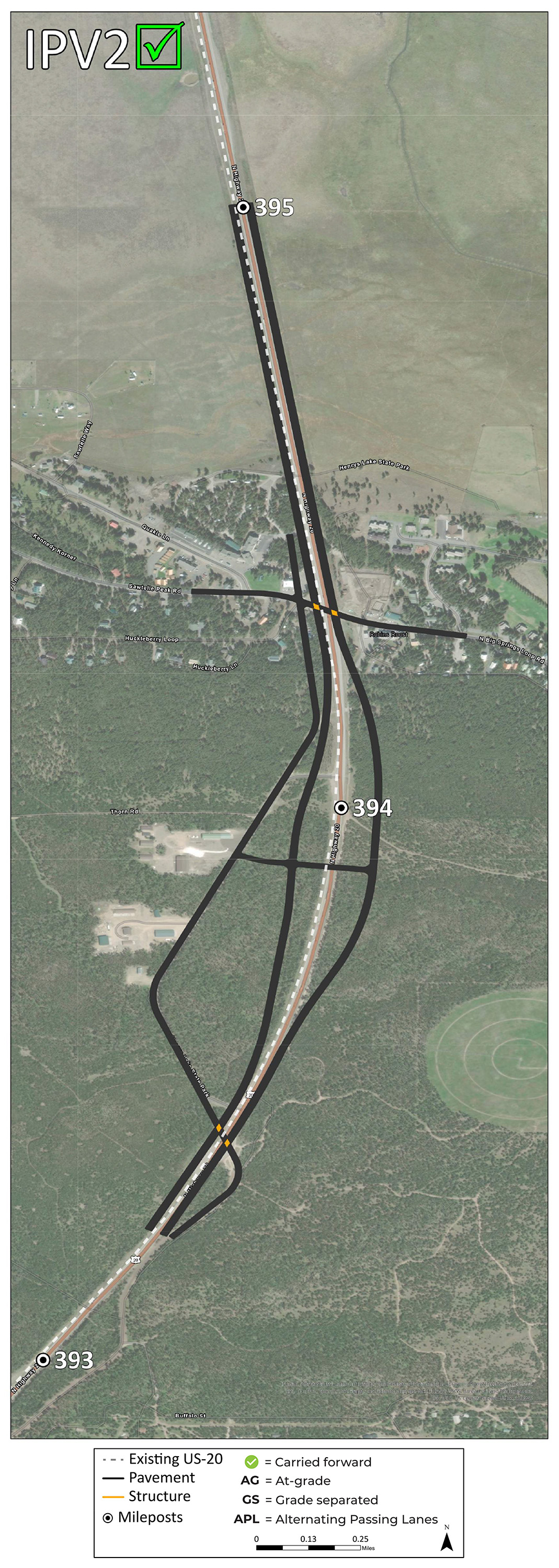
Click image to enlarge
| Island Park Village (IPV) | ||||
|---|---|---|---|---|
| At-grade (AG), Grade separated (GS), Alternating Passing Lanes (APL) | ||||
| Level 3 Alternatives | Roadway Lanes | Action | Reasons | |
| IPV0 | AG | Carried Forward |
|
|
| IPV1 | APL | Does Not Advance |
|
|
| IPV2 | AG & GS | Carried Forward |
Additional Items to Consider:
|
|
Red Rock Road (RR)
 RR2
RR2

Click image to enlarge
| Red Rock Road (RR) | ||||
|---|---|---|---|---|
| At-grade (AG), Grade separated (GS), Alternating Passing Lanes (APL) | ||||
| Level 3 Alternatives | Roadway Lanes | Action | Reasons | |
| RR0 | AG | Carried Forward |
|
|
| RR1 | APL | Does Not Advance |
|
|
| RR2 | AG & GS | Carried Forward |
Additional Items to Consider:
|
|
Valley View Area (previously Red Rock Road)
 VV3
VV3

Click image to enlarge
| Valley View Area (previously Red Rock Road) | ||||
|---|---|---|---|---|
| At-grade (AG), Grade separated (GS), Alternating Passing Lanes (APL) | ||||
| Level 3 Alternatives | Roadway Lanes | Action | Reasons | |
| RR0 | AG | Carried Forward |
|
|
| RR1 | APL | Does Not Advance |
|
|
| RR2 | AG & GS | Carried Forward |
Additional Items to Consider:
|
|
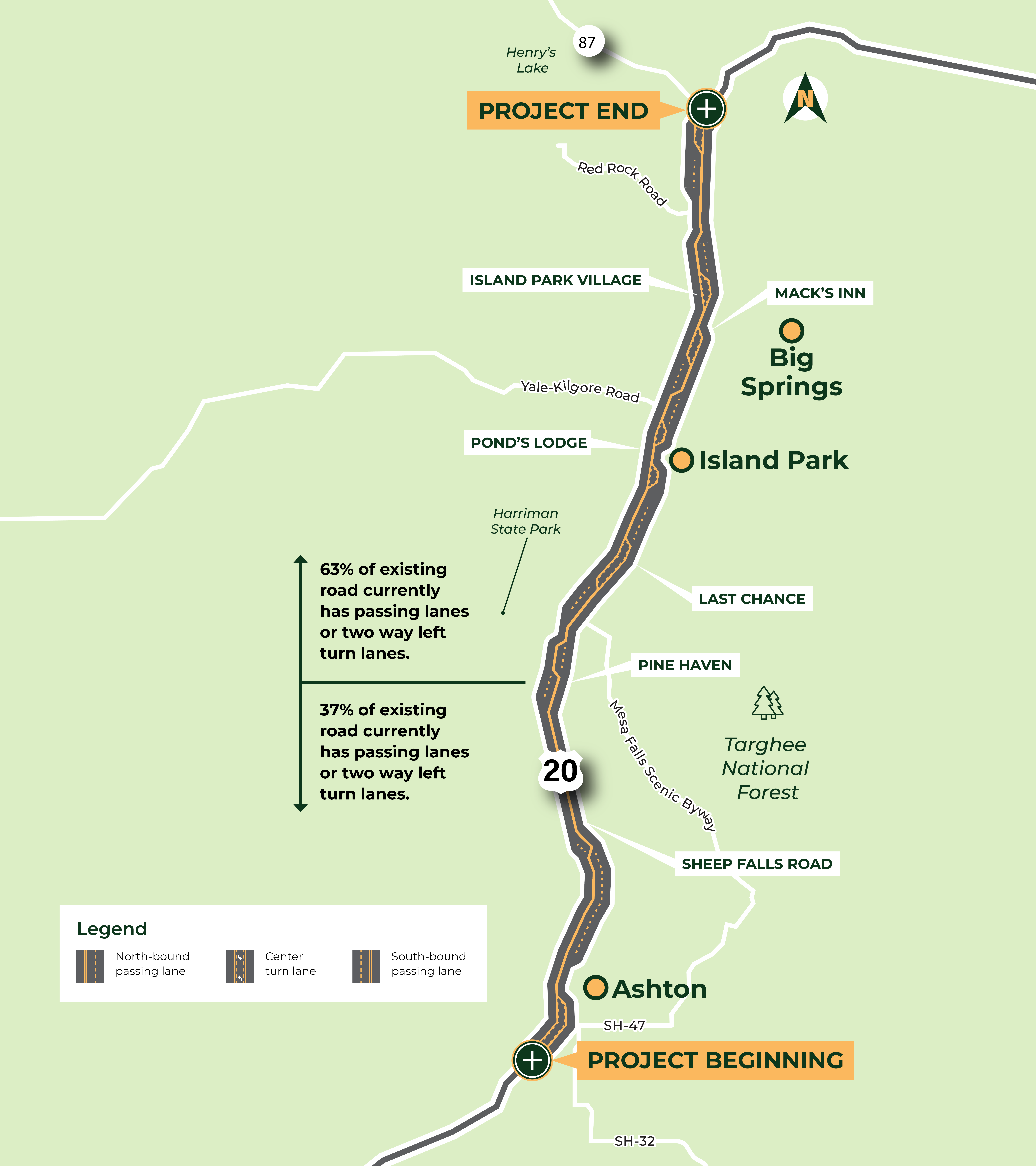
Alternating Passing Lanes
Why did the stakeholder screening group agree this option is least beneficial and should not be recommended for environmental studies and related costs?:
- Doesn’t meet FHWA Purpose and Need requirements including safety and mobility.
- Traffic data currently indicates high seasonal volumes and by 2050 excessive congestion and delays.
- Designers have found this inconsistent lanes design creates high risk crash zones for traffic in both directions.
- The other alternatives per reviewers eliminate the above risks and have more safety and mobility benefits for the investment over decades helping the community and US20 travelers.
- ITD experts are available to discuss these traffic issues and answer questions.
Click image to enlarge
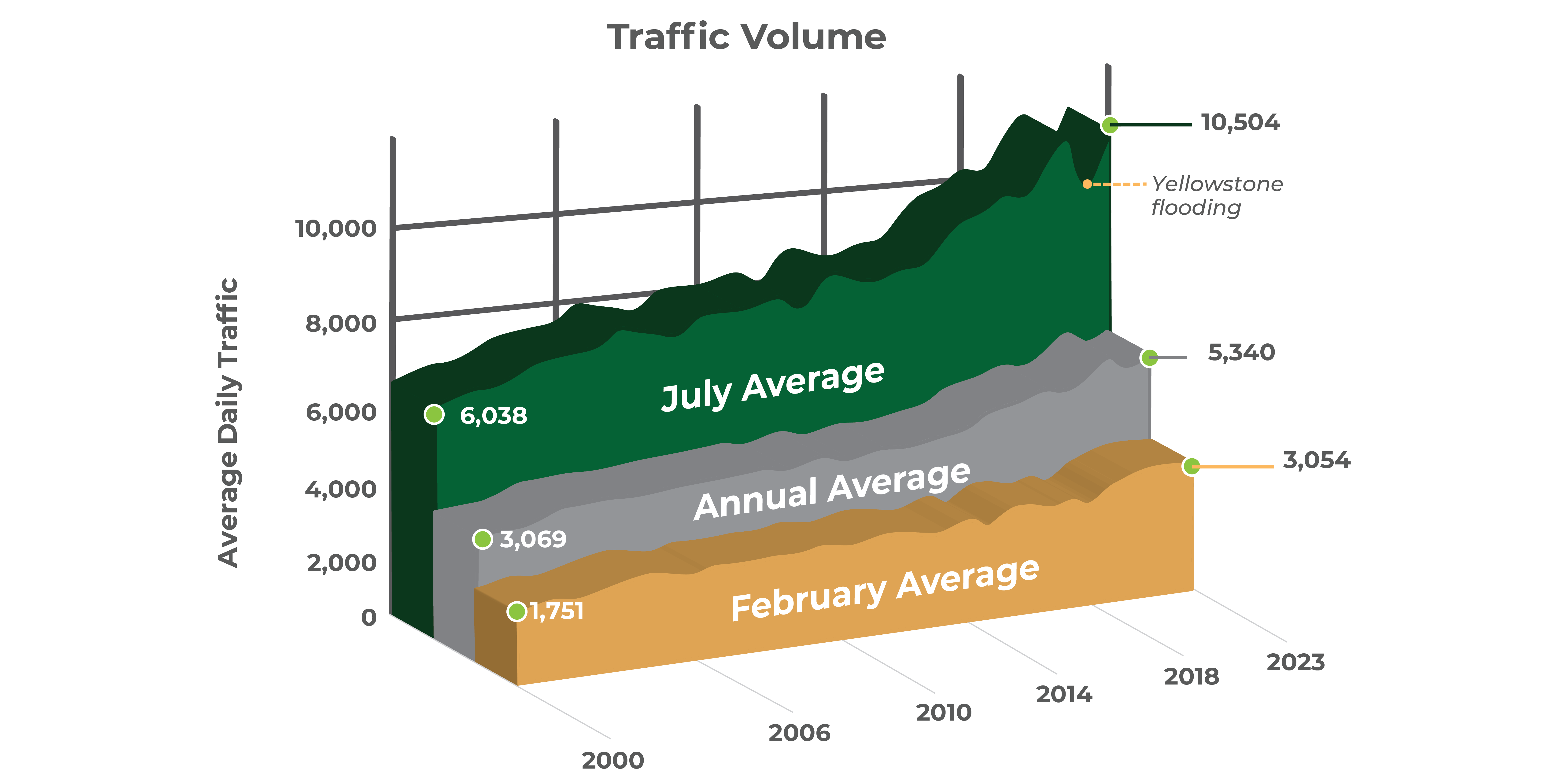
Traffic Data

ITD will design improvements to address peak volumes and reduce congestion and delays
Click image to enlarge
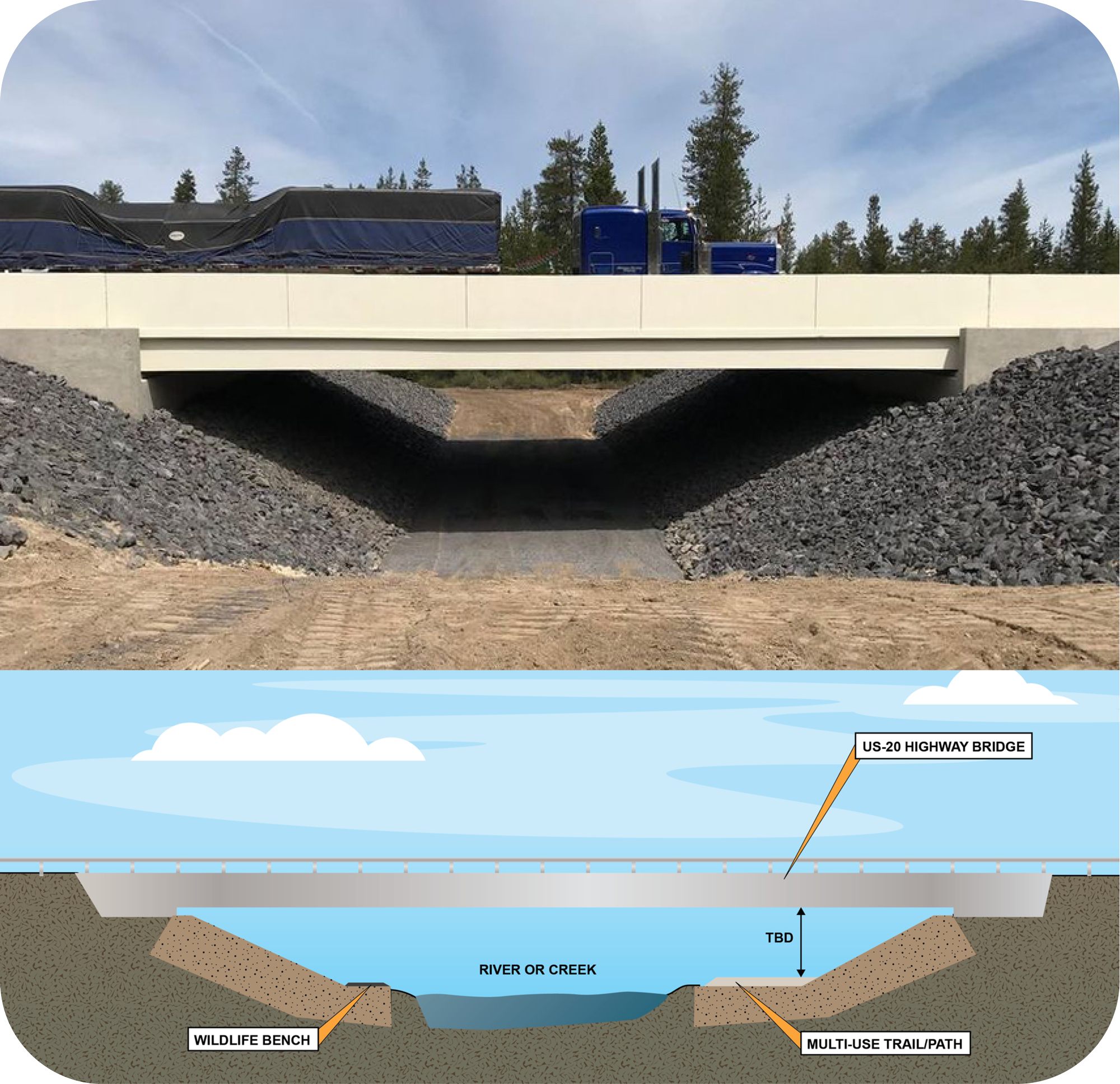
Multi-Use Crossings
ITD is evaluating:
- Multi-use crossing opportunities at trails, pathways, and bridge locations that intersect US-20
- Cyclists
- Pedestrians
- Snowmobilers
- ATV/UTV riders
- Equestrians
- Snowshoers
- Fishermen and other sportsmen
- Hikers and other trail users
- Wildlife crossing infrastructure
- ITD is evaluating movement and wildlife migration information. Technical assistance is being provided by the U.S. Forest Service, U.S. Fish and Wildlife Service, and Idaho Fish and Game.
Click image to enlarge
Environmental Considerations/11 Criteria
Alternatives will be evaluated through a screening process to determine how well they meet the project’s draft purpose and need. The screening process includes evaluating each alternative based on the following 11 environmental criteria.
- Visual Resources
- Agricultural and Forest Resources
- Air Quality
- Biological Resources
- Cultural Resources
- Geology and Soils
- Hazards and Hazardous Materials
- Hydrology and Water Quality
- Land Use and Transportation Planning
- Noise
- Social and Economic Resources
What's Next?
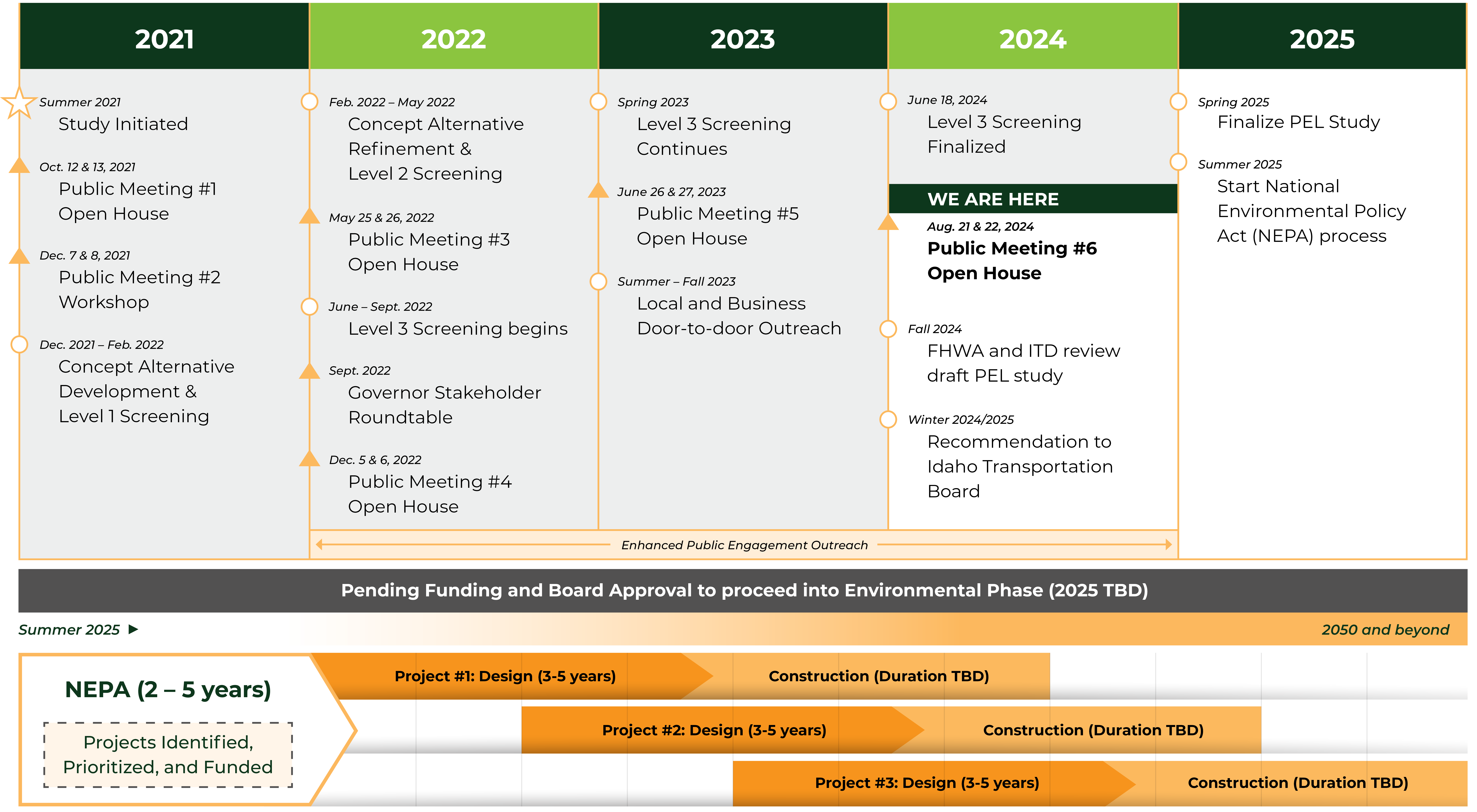
Click image to enlarge
Stay Involved
Please share ideas about the project. Public input is an important part of the decision-making process along with technical information and engineering best-practices.
For more information, visit the project page.
Comments
If you have questions please contact the project team.
Use the comment button at the top right of this meeting to view the comment form where you can submit comments. You can also submit comments via email to comments@us20ashtonto87.com
or mail them to:
ITD District 6 C/O Gregg Bowman
206 N. Yellowstone Highway
Rigby, ID 83442
While your comments are always welcome, they can be best utilized if received by September 5, 2024.
While your comments are always welcome, they can be best utilized if received by September 5, 2024.